

Description
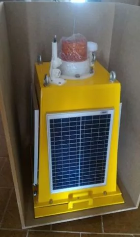
The MS4580 is a self powered flashlight designed with state-of-the-art technologies to offer many possibilities and ease of communication integration over 10Base-T TPC/IP and Wifi connections that allows full configuration through your Webserver. Its MS4510 or MS4515 flashlight allows applications in ranges from 3 to 18nm equipped with 4w Super LEDs in Red, Green, Blue and White, (RGBW) with 360° degrees horizontal and 5° vertical, intensity control with 256 flash settings, microprocessed and webServer more advanced on the market for configurations. The MS4580 module is a base equipped with an 80W solar power system with 115Ah capacity battery for the use of Flashlights (MS451X, not included), Optional Weather Modules (Wind Speed, Wind Direction, Temperature, Humidity, Barometer Pressure, Dewpoint and Windchill, measuring solar radiation, Pluviometer), Inercial instrumentation (Accelerometers, Gyroscope, Barometric Pressure, Compass Temperature, Odometer, Profundimetro, etc.), GSM Telemetry and allows to use AIS Modules AtoN - AtoN - Aids for Navigation Report or "Navigation Aid" with messages established by ITU-R M.1371 with support for messages 21, 6, 7, 8, 12, 13, 14, 25, as well as the identity of The AtoN, the type of AtoN, and its position, this message also carries a digital flag to indicate whether a floating AtoN is out of its position. Message 21 will increasingly be an important part of navigation, which is being developed by IMO (International Maritime Organization) and IALA. All units of these modules transmit the messages in a range that is user configurable. AtoN Module Monitoring ITU-R M.1371 defines Message 6 as a binary addressed message, used for sending data from one station to another AIS. The module uses Message 6 to carry comprehensive information about the operational status of a flashlight, its power supply, and etc. The AtoN authority can have its own tracking center, or it can assign the control task to a Vessel Traffic Services (VTS) center or other existing facility. Whatever the location, the monitoring data for each AtoN AIS site can be easily transferred to the required point over the AIS network. Early indication of failures or failure of a flashlight or power supply allows the authority to respond quickly to maintenance, increasing the availability of the AtoN service. Meteorological and hydrological Reports Message 8 is defined by ITU-R M.1371 as a binary message to transmit, which means that it is intended for multiple users. The IMO (International Maritime Organization) has defined a version of Message 8 for the transport of meteorological and hydrological data. The module can transmit this message at set intervals during drive configuration. External sensors are naturally needed to obtain most weather and hydrological data, module can provide complete systems easily through its internal Ethernet structure that compatible with all tcp/IP based devices in the family. The module can measure wave height, period and direction using its internal operating system and its tilt and gyroscope sensors and add to weather and hydrological messages (wind speed, wind direction, air temperature, water temperature, air humidity, relative humidity, barometer, magnetic compass, light intensity, rain gauge, etc.) for broadcasting, so that no external sensor is required. The user should consider that wave accuracy can be affected by the movement of the buoy. Autonomous Solar Power Supply The module provides its own autonomous power source to power your system through 4 side solar cells, its charge controller and its fully sealed stationary battery, mounted in its enclosure. GPS/GLONASS Optionally the module can contain a GPS/GLONASS with 167 channels, independent of a Flashlight, capable of receiving satellites from the American constellation (GPS) and the Russian constellation (GLONASS) with excellent stability and accuracy of a maximum of 2.5 meters. GLONASS is the satellite navigation system that has been developed by Russia since 1976 and today has 24 satellites in orbit, responsible for providing positioning data. With the end of the Soviet Union, the project was virtually abandoned, but during the last few years, under Vladimir Putin, the restoration of the system was done with high priority, with GLONASS today being the most expensive program funded by the Russian Federal Space Agency, reaching cost about a third of its budget in 2010. Its operation is very similar to the American GPS, because it has 24 satellites that are distributed between three layers with 8 satellites in each, and the position of the equipment is formed by at least 3 of them through a process called trilateration, which ensures the accuracy of positioning the system. In December 2007, 14 new new generation satellites were launched to make up the system and its global coverage was completed in 2011 after the restoration ended, making it a great alternative to GPS. One of the advantages to using GLONASS for other solutions is the positioning accuracy, because after the system improvements, it is able to offer its maximum resolution to civilian use, which does not occur with GPS, because the United States limits the accuracy capacity of its system, and as for GALILEO, positioning system developed by the European Union, it is rumored that more advanced use will become paid. Optional useless instruments (Inclinometer, Gyroscope, Compass, Barometer, etc.) The module can be equipped with a device of type "MEMs with 3-axis MEMS accelerometer", "3-axis MEMS gyroscope", a "Digital Motion Processor (DMP)", "3-Axis Digital Compass" and a "Barometric Pressure Sensor", which allows additional information about its inercial position as well as measuring wave height, magnetic direction and local barometric pressure. Wifi - Local Link It is also available the feature of a Wifi communication device such as Acess Pointer - AP to allow local communication with any portable device of computer, tablet or smartphone. GSM - Remote Link This module is also equipped with a GSM MODEM that allows the data link through a telephony network within reach of AtoN or Beacon AIS (Lighthouse). Lanterns Its system also allows to equip with a nautical signaling lantern obeying iala configuration standards with full autonomy through the module's solar power system. Recommended programs There are several systems available on the market to visualize and control vessel traffic through the AIS system, we recommend for example an open development system "OpenCPN". Another tool available to implement a TCP/IP NetworkEd AIS Server is the "SiiTech AIS Server". Weather Station: Temperature range: -40.0°C to +65.0°C (-40°F to +149°F) Humidity range: 5% ~ 99% RH Barometer: 300 to 1000hPa (+9000m to -500 at sea level) Wind speed 0 ~90 (mph, m/s, km/h, knots, Beaufort) Rainfall: Indication of rain volume: 0-9999 mm, resolution: 0.3 mm Wind speed: 0 ~ 120 mph (190 km) Basic Specification: Solar System: 80W (4 X 20W) Battery: DF1500 12Vdc/115Ah Inner Rack: Anodized Aluminum Accommodation: Box in PU Degree of Protection: IP45 Optional Modules: AIS: AMEC MANDO-301/303 Flashlights: MS451X, MS4595... GSM: H20 Homtecs Weather: MS1112 (Wind Speed, Wind Direction, Temperature, Humidity, Pressure Barometer, Dewpoint and Windchill, measuring solar radiation, Pluviometer) Instruments: MS1145 and/or MS1109 (Accelerometers, Gyroscope, Barometric Pressure, Temperature Compass, Odometer, Profundimeter, etc.) **We are manufacturer
- Buoy
- Maritima
- Marine
- beaconing
- Signaling
- signal light
- navigation
- telemetry maritima
Production Capacity:
10
Delivery Timeframe:
Within 45 Days
Incoterms:
FOB - Free on Board
Packaging Details:
1500MM X 600MM X 600MM PESO: 60KG
More about
Extrom Technology
0-10
Employees
Not informed
Not informed
Year
Established
Business type
- Industry / Manufacturer
- Business Service
Keywords
- IoT
- Maritime Beaconing
- Signaling and Navigation Flashlight
- Instrumentation
- Navigation
- LED
- Integration
- Telemetry
- Industry 4.0
- Geotechnics. Ver Mais
Contact and location
-
 Francisco ********
-
+55 21********
-
Maricá / RJ | Brazil
